Unearthing the City of King Midas
미다스 왕의 도시 발굴
By James Kensington Sat, Dec 13, 2014
알렉스 대왕이 BC 333 에 고르디온(Gordiaon)을 들어왔을
때, 도시는 이미 고대였고 이전 영광의 흔적만 있었다. 이 때 까지 페르시아 제국 다리우스 3세의 영역으로 다스려졌다. 고르디온은 표식 위치 및 군대가 쉴 곳이었다. 여기부서 페르시아와 전투를 하기 위해 실리시아로 진군할 병력을 모으려고 했지만 한 가지 중요한 것을 성취하기 전에 고대 프리기아 왕의 궁전 내부에 있는 폴을 쪼이는 전설적인 매듭을 풀려고 하지 않았다. 예언에 따르면 매듭을 푸는 사람은 아시의 모든 곳을 통치하게 된다고 한다.
프리기아의 옛 수도인 고르디온은 또 다른 얘기로 유명하게 알려져있다. 고대 그리스 신화에 모든 것을 건더리면 금으로 변화하는 것으로 알려진 전설의 미다스 왕이 프리기아에 있었다. Other than recorded myth and literature, there is little direct, indisputable evidence of the existence of the King Midas of Greek mythology. But historical sources tell of three different kings of Phrygia by the name of Midas, with one who ruled Phrygia in the late 8th century BCE well known from Greek and Assyrian sources. Of the reality of the Phrygian kingdom itself, there is plentiful physical and archaeological evidence, and much of it can be found at the ancient archaeological site of Gordion, otherwise known as Gordium. Located in present-day west central Turkey near modern Yassıhüyük about 70 – 80 km southwest of Ankara, its ruins stand as a testament to Phrygian monumental architecture, an urban presence spanning across two kilometers, dominated by massive buildings and fortifications and over 100 burial mounds, lying strategically as it were where an ancient well-traveled road crossed the Sakarya river between Lydia and Assyria/Babylonia. It was the capital and largest city of an Anatolian kingdom, whose power peaked during the late 8th century BCE under the historical king Midas, when it dominated western and central Anatolia and rivaled Assyria and Urartu to its east for the eastern regions of Anatolia. More anciently, during the Bronze Age, it allied itself with the Trojans, according to Homer’s The Iliad, to battle the Achaeans.
Today, Gordion’s population is history. It’s inhabitants now consist mostly of a seasonal influx of archaeologists, conservators, excavators, and a mix of other experts and specialists whose tasks revolve around systematically uncovering what remains of the city, restoring and preserving what can be pieced back together again, and showcasing its finds in an onsite museum.
But this work goes back decades. Historically, it has been the focus of on-and-off excavations since it was discovered in 1893 by Alfred Körte, who initiated exploratory excavations at the site in 1900. The best known excavations were conducted under the directorship of Rodney Young of the University of Pennsylvania Museum of Archaeology and Anthropology (Penn Museum) beginning in the 1950's. His excavations over 17 seasons uncovered major sections of the Phrygian period Citadel Mound, including overlying Hellenistic towns, and a mudbrick fortress and defensive walls of a Lower Town near the Citadel. Young also uncovered no less than 30 burial tumuli, which included the sensational royal 'Tumulus MM' (the “Midas Mound”) and a nearby tomb of a wealthy Phrygian child (‘Tumulus P’).
Now, under the directorship of Brian Rose of the University of Pennsylvania, teams have, since 2007, uncovered additional finds. In the last two seasons, beginning in 2013 with renewed excavations at the south side of the Citadel Mound, solid new evidence has emerged for additional defensive works, including massive defensive walls, part of a road, and industrial work spaces dated back to some of the earliest periods of the site, all adding to the historical and chronological sequence of the site.
"Gordion’s historical significance derives from its very long and complex sequence of occupation, with seven successive settlements spanning a period of nearly 4500 years," says Rose. "What we discovered was a large glacis or stepped terrace wall over 2.5 m in height, dating to the Early Phrygian period, that supported a substantial fortification wall nearly 3 m. wide. This has proven that the western side of the mound was fortified, and that those fortifications had already been established in the Early Phrygian period (9th c. B.C.), neither of which had been known previously."*
Other massive fortifications, particularly on the eastern side of the Citadel Mound, had already been uncovered through previous expeditions. But the new features now expanded the emerging picture of the Gordion defensive fabric. Rose’s excavations revealed fortifications spanning the entire time period of Phrygian rule in the region. "We were fortunate this year in uncovering new fortifications dating to three different periods: Early Phrygian (9th c. BC), Middle Phrygian (8th c. BC) and Late Phrygian (6th c. BC).......it is already clear that the scale of the citadel fortifications throughout the entire Phrygian period was much more ambitious than formerly suspected," wrote Rose in a recent report of the latest, 2014 season.*
 Aerial view of the newly excavated Early, Middle, and Late Phrygian fortifications on the southern side of the Citadel Mound. Photo by Lucas Stephens. (Picture credit: Penn Museum Gordion Archive, 2014-Area 1 Aerial 5)
 View of the Early and Middle Phrygian fortifications on the southern side of the Citadel Mound, looking east. Tumulus MM (Midas Mound) is visible at upper right. Photo by Brian Rose. (Picture credit: Penn Museum Gordion Archive, 2014-7483)
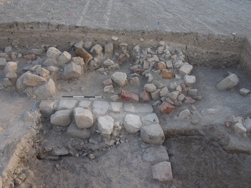 View of collapsed colored stones newly discovered behind the Middle Phrygian fortification wall on the southern side of the Citadel Mound, looking north. Photo by Gebhard Bieg. (Picture credit: Penn Museum Gordion Archive, 2014-1579)
Additionally, Rose's team excavated a sondage trench through what has been designated the Terrace Building, a structure discovered during previous excavations and thought to be a building where industrial activities occurred. They uncovered a large industrial kiln surrounded by ceramic remains that helped to date the feature to the Early Iron Age, or the 11th century BCE. Above and east of the kiln they excavated an Early Iron Age house structure, which contained objects related to textile manufacture, such as spindle whorls and loom weights, and a bell-shaped pit that contained fragments of Early Iron Age handmade wares and animal bones. "The evidence yielded by the sondage demonstrates that there was considerable industrial activity in this area before the Terrace Building was constructed, beginning in the 11th c. B.C.," wrote Rose in a recent newsletter report.*
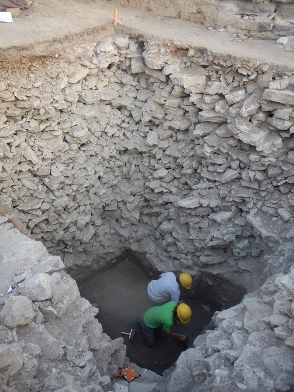 Excavators Olivia Hayden and Jane Gordion digging beneath the rubble fill in the Terrace Building sondage. Photo by Brian Rose. Picture credit: Penn Museum Gordion Archive, 2014-4142)
 Excavators Kate Morgan, Olivia Hayden, and Jane Gordion uncovering the Early Iron Age house below the rubble fill under the Terrace Building, looking east. The upper part of a kiln is visible at the bottom. Photo by Gebhard Bieg. (Picture credit: Penn Museum Gordion Archive, 2014-6666)
 Aerial view of the Citadel Mound of Gordion in 2014. Photo by Lucas Stephens. (Picture credit: Penn Museum Gordion Archive, 2014-CM Aerial 1)
The Outer Town
The Citadel Mound tells only part of the story of urban Gordion. Beyond and below the imposing defensive bastion thrived a city of people who left vestiges of other monumental public buildings and domestic structures, a Gordion far more robust and expansive than a single citadel. During Young’s excavations decades before at a small mound (called ‘Küçük Höyük’) near the Citadel, archaeologists revealed a mudbrick fortress set atop a mudbrick bastion, interpreted as a probable ancient Lydian construction dated to the late 7th or early 6th century BCE. They found that its associated walls, including connected ditch-work, actually enclosed a settlement area they designated as the Lower Town, an area consisting of evidence of residential, or domestic, structures. Remote sensing has since successfully defined the fortification walls, streets and buildings of this settlement area.
Most recently, a team under the direction of Stefan Giese and Christian Huebner of GGH in Freiburg, Germany, conducted a geophysical survey that yielded traces of yet another associated settlement area, an 'Outer Town', using magnetometry and electric resistivity techniques. The Outer Town is a second residential area with detected remains just west of the Lower Town. What they found was no less revelatory than the new Citadel Mound discoveries. They detected signs that this Outer Town was "bordered by a ditch with a defensive wall on its interior"*, which the team believes surrounded the entire Outer Town. And this was not all—the findings included other features that suggested a monumental fort. “At the western end of the Outer Town,” write Rose, et al., “nearly 1 km to the west of the citadel mound, we discovered the presence of what we interpret as a monumental fort, approximately the same size as the fort of Küçük Höyük (the “minor mound”) in the Lower Town.” The new findings seemed to match the pattern found previously with the Lower Town, though they appeared to have been planned as separate residential areas demarcated by a fortification wall between them.
Did these findings suggest or imply something about ancient Godion’s social structure? The investigators have no answers, yet. But further surveys and excavation may shed some light.
 The fortifications of Gordion detected through remote sensing. The new results in the Outer Town appear at left. Plan by GGH. (Picture credit: Penn Museum Gordion Archive, GGH 2014 Map 4)
The Conservation Task
The combined forces of time, weather, exposure and other elements take their inevitable toll on archaeological sites. Gordion has been no exception. Perhaps most dramatic were the effects caused by a major earthquake in 1999, which left a significant bulge in the masonry of the Early Phrygian Gate. Because of its monumentality and importance as the best-preserved citadel gate of Iron Age Asia Minor, it has arguably become one of the most urgent tasks for conservators at the site. “We realized that strategic intervention was necessary if a collapse was to be averted, now and in the future,” wrote Rose, et al.* With the help of a number of organizations, individuals, and consulting firms, solid steps have been taken to shore up the structure, which included erection of a new scaffolding system, removing displaced stones, repairing deteriorated or damaged stones, and inserting steel support straps, among other measures.
 Erection of the new scaffolding at the Early Phrygian Citadel Gate prior to the beginning of conservation. Photo by Brian Rose. (Picture credit: Penn Museum Gordion Archive, 2014-4535)
Other damage was caused by more ancient events, such as an 800 BCE conflagration that damaged the masonry foundations of the Early Phrygian Terrace Building, which anciently was an 8-room industrial complex. Since 2009, conservators and other expert workers have been busy repairing and rebuilding the foundations and walls of the various rooms within the structure.
Like that of other major archaeological sites, the artwork of Gordion has drawn special attention from conservators. In 1956, Young excavated a remarkable late 9th century BCE pebble mosaic near the Terrace Building, a piece that, according to archaeologists, featured “a series of polychromatic geometric designs that most likely echo the kinds of textiles that would have been produced in the adjacent Terrace Building.”* This effort has involved application of the latest restoration techniques by experts specially trained in the art of repair and restoration.
 Sema Küreckçi and Meredith Keller cleaning the pebble mosaic from Megaron 2 (an Early Phrygian period structure). Photo by Gebhard Bieg. (Picture credit: Penn Museum Gordion Archive, 2014-4408)
For Rose and colleagues, there is much more work to do. Countless features and artifacts are left to be uncovered, work that will occupy researchers for many years ahead. But in the short time span of Rose’s research at the site thus far, much has already been accomplished. Popular Archaeology asked Rose what he thought were some of the most important discoveries made since renewed excavations began in 2007.
“We discovered four inscriptions in Tumulus MM, the tomb that probably held the body of Midas' father [Gordias, the founder of Gordion],” Rose replied. “These may be the signatures of the officials who oversaw the burial. We've also been able to determine that the Phrygians used a special pigment to color their clothing, which gave them a golden sheen. This may tie in to the legend of Midas's Golden Touch.” More recent investigations in the area of the ancient site have uncovered another major tumulus. About 17 meters in height, and like Tumulus MM, this one also features a wooden burial chamber within. Initially found as a result of illegal looting excavations by treasure hunters, Rose now hopes to conduct controlled archaeological salvage excavations at the mound to determine more about its nature and the possible remains of its human occupant. Although detailed information about it is still forthcoming, Rose suggests, based on data thus far acquired, that the new tumulus dates to the 8th century B.C. and may contain the remains of a Phrygian king.
But perhaps the most far-reaching discovery revolves around the newly found immensity of the ancient city itself. “We have been able to determine that the city was twice as large as we previously thought, because we've identified the outer fortifications of the city through remote sensing.” With this in mind, one of Rose’s more immediate goals relates to developing a city plan of Gordion based on the available and emerging data. “We have not yet determined the city plan of the settlement," says Rose, "but by combining excavation with remote sensing (radar, magnetic prospection), we should be able to do it."
__________________________
More information about Gordion and the Gordion Archaeological Project can be found at the project website. For individuals interested in making a donation to the project, see the Friends of Gordion page. Friends of Gordion receive an annual newsletter about the most recent results of research and excavation and may also receive special guided tours of the site.
__________________________________
- * Rose, C. Brian and Gürsan-Salzman, Ayse, Friends of Gordion Newsletter, September 2014
_______________________________________________________
A R T I C L E S U P P L E M E N T

The Funeral of Tumulus MM
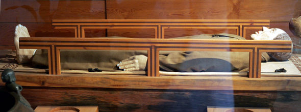
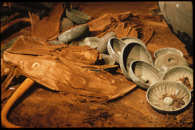
One of the most spectacular discoveries at the Gordion archaeological site came when Rodney Young of the University of Pennsylvania opened an imposing tumulus mound in 1957 known as Tumulus MM, today interpreted to have been the probable tomb of Gordias, founder of the city of Gordion and father of the legendary King Midas. Within a wooden chamber of the tumulus tomb, Young and his colleagues found the remains of a man determined to have died when he was between 60 and 65 years old. His remains had been placed on a pile of dyed textiles inside a wooden coffin. The coffin was accompanied by 14 remarkably well-preserved items of wood furniture, thought to have been dining and serving tables used at a funerary banquet before the interment. Also found were 3 large cauldrons on iron tripod stands, 19 large two-handled bowls, 100 bronze drinking bowls, round-bottomed buckets, 19 juglets, 2 jugs, a ram-headed situla, and a lion-headed situla. Further analysis indicated that vessels had contained a beverage made from a mixture of honey mead, grape wine, and barley beer. Eighteen ceramic jars showed evidence of a spicy funerary feast of lentils and barbecued sheep or goat stew. It was, according to the archaeologists, evidence of an elaborate banquet fit for a king.
 Section of Tumulus MM from the north, showing the open trench and tunnel cut during the excavation of 1957. Drawing by Richard Liebhart, after Young 1981: fig. 51. (Picture credit: Penn Museum Gordion Archive 102811, and Richard Liebhart)
 Tumulus MM: Center cross-section construction of the tomb chamber complex (looking north). Drawing by Richard Liebhart. (Picture credit: Gordion Archaeological Project, Richard Liebhart)
 Above and below: Tumulus MM, 1957: Inlaid table as found, with bronze vessels. 청동 항아리 중동 프리기아 기간 c. 740 B.C.E. (Penn Museum Gordion Archive)

 Above: Inlaid table, Tumulus MM, reconstruction drawing by Elizabeth Simpson, 1985. Copyright E. Simpson.
 Above: Inlaid table from Tumulus MM reconstructed for display, 1989. Courtesy Gordion Furniture Project.
 Above: Tumulus MM, 1957: Remains of a plain table, with bronze bowls, as found. Middle Phrygian period, c. 740 B.C.E. (Penn Museum Gordion Archive, G-2376)
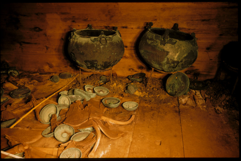 Tumulus MM, 1957: Southern end of the tomb chamber, with bronze cauldrons against the wall, the remains of plain Tables in front, and bowls and jugs scattered across the floor. Middle Phrygian period, c. 740 B.C.E. (Penn Museum Gordion Archive, G-2385)
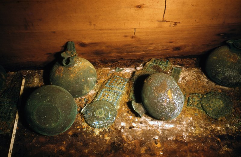 Tumulus MM, 1957: Bronze-studded leather belts with decorative bronze disc attachments, and bronze trefoil- mouthed jugs, on the floor where they had fallen in antiquity. Middle Phrygian period, c. 740 B.C.E. (Penn Museum Gordion Archive, G-2404)
 Tumulus MM, 1957: Wooden serving stands in place: stand A at right and stand B at left. Middle Phrygian period, c. 740 B.C.E. (Penn Museum Gordion Archive, G-2343)
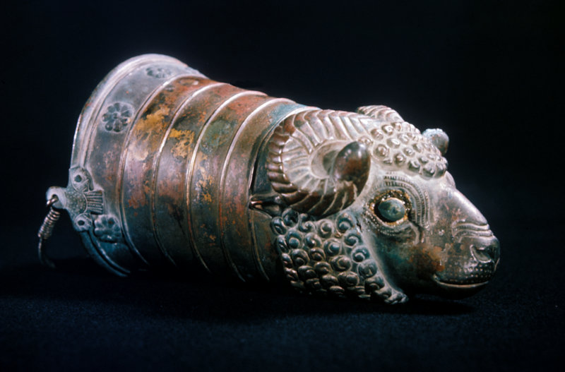 Tumulus MM, 1957: Bronze ram’s-head situla, after cleaning by the British Museum. Middle Phrygian period, c. 740 B.C.E. (Penn Museum Gordion Archive, G-3008)
Decades later, in 2007, Richard Liebhart, Rose and colleagues discovered four Phrygian inscriptions incised on several timbers while investigating the northwest corner of the outer tomb chamber. "The names [NANA, MYKSOS, SI↑IDOS, and KYRYNIS] had clearly been scratched into the beams before they were set in place around 740 BCE," wrote the researchers about the find. "The hand of the inscriber was steady and sure, and all the words appear to have been inscribed by the same man, at approximately the same size, with SI↑IDOS written slightly larger than the other words. The SI↑IDOS beam was also probably the first one to have been placed on the tomb after the funeral ended." Rose and colleagues suggest that SI↑IDOS was likely a prominent man in the community of Gordion.
"One can think of this as an early prototype of the Memorial Name Books that are still used in funerals today," wrote Rose and colleagues.**
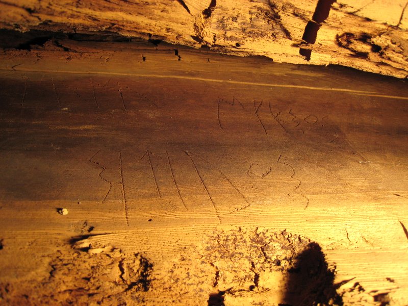 Above and below: The names inscribed on the roof beam in Tumulus MM. Photos by Richard Liebhart (Picture credit: Gordion Archaeological Project, Richard Liebhart)

 The Royal Funeral Ceremony Banquet. Reconstruction of the funeral ceremony held before the Tumulus MM burial. Painting by Greg Harlin based on drawings by Elizabeth Simpson, 2001. Copyright G. Harlin and E. Simpson.